The hidden secret on Antarctica (Revealed by Piri Reis Map)
dheeraj jain
ISTQB® Certified | System Integration & Test Engg. | Medical Devices | Team Player | I help to identify early defects in the software
Current belief on Antarctica
We all know Antarctica is the coldest, farthest most non-habitable place on earth. Although it is 5th largest continent on earth in size only a few thousand people live here. It is discovered in 1820. For millions of years, it is covered by Ice. Life is very difficult in Antarctica. But what if all this information is not correct What if till now we all have been taught wrong about Antarctica. If Antarctica was discovered in the 18th Century then there should not be any map exist which can represent Antarctica on map
Discovery of Secret
Professor Charles H. Hapgood was the first person who notices this secret while studying Piri Reis Map. He raised a request for a re-evaluation of the Piri Reis Map. Below is the response from Keene College, Keene, New Hampshire after re-evaluation of the Piri Reis Map.

If Queen Maud Land was mapped before it was covered by ice, the original cartography must have been done an extraordinarily long time ago. How long ago exactly? We can believe this information as Piri Reis Map, which is a genuine document, not a hoax of any kind, was made at Constantinople in AD 1513.3. Normal belief about Antarctica has it that the Antarctic ice-cap, in its present extent and form, is millions of years old. On closer examination, this notion turns out to be seriously flawed—so seriously that we need not assume the map drawn by Admiral Piri Reis depicts Queen Maud Land as it looked millions of years in the past.

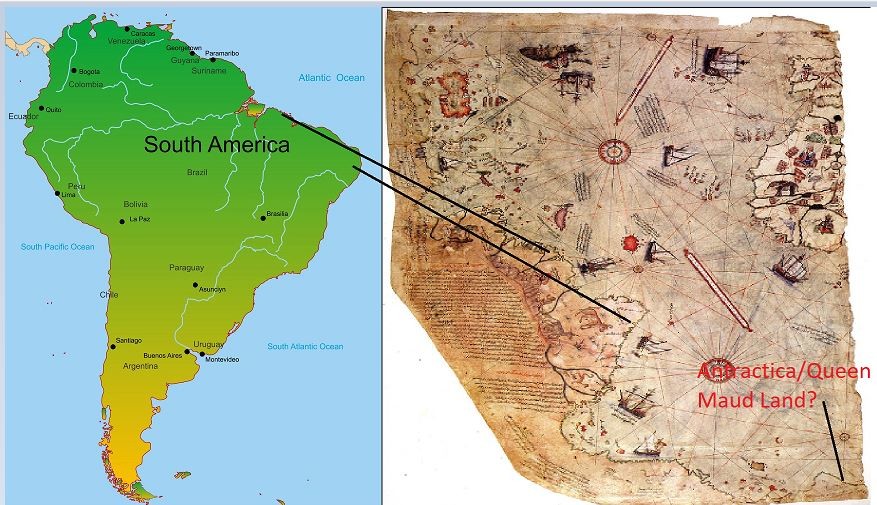
Piri Reis Original Map

Piri Reis Original Map with Current Map

Few supporting facts from Book Finger Prints of GOD
- The Piri Reis Map, which is a genuine document, not a hoax of any kind, was made at Constantinople in AD 1513.3
- It focuses on the western coast of Africa, the eastern coast of South America and the northern coast of Antarctica.
- Piri Reis could not have acquired his information on this latter region from contemporary explorers because Antarctica remained undiscovered until AD 1818,4 more than 300 years after he drew the map.
- The ice-free coast of Queen Maud Land shown in the map is a colossal puzzle because the geological evidence confirms that the latest date it could have been surveyed and charted in an ice-free condition is 4000 BC
- It is not possible to pinpoint the earliest date that such a task could have been accomplished, but it seems that the Queen Maud Land littoral may have remained in a stable, unglaciated condition for at least 9000 years before the spreading ice-cap swallowed it entirely.
Why I should believe in this Maps
According to Charles H. Hapgood
- Antarctica was not always covered with ice and was at one time much warmer than it is today.
- It was warm because it was not physically located at the South Pole in that period. Instead, it was approximately 2000 miles farther north. This ‘would have put it outside the Antarctic Circle in a temperate or cold temperate climate’
- The continent moved to its present position inside the Antarctic Circle as a result of a mechanism known as ‘earth-crust displacement’. This mechanism, in no sense to be confused with plate-tectonics or ‘continental drift’, is one whereby the lithosphere, the whole outer crust of the earth, ‘may be displaced at times, moving over the soft inner body, much as the skin of an orange, if it were loose, might shift over the inner part of the orange all in one piece’
- During the envisaged southwards movement of Antarctica brought about by earth-crust displacement, the continent would gradually have grown colder, an ice-cap forming and remorselessly expanding over several thousands of years until it attained its present dimensions.
There is one big question remains here. Why there was no further investigation happened on the Piri Reis map. Are there any secret lies? There are many other studies coming up which says, Antarctica temperature in was much higher than today's temperature. If it was higher then how many centuries before?
Current student in DeVry University's Medical Billing & Coding Program. Anticipated graduation date is August 2024.
6moAlso, the Queen Maud claim doesn't make much sense since Norway didn't explore Antarctica until 1929 and didn't claim any land until 1939. We all know it was covered in ice when Queen Maud land was claimed and this map depicts this land as ice-free and still connected to South America. I do however love the last sentence in the letter from the university "We have no idea how the data on this map can be reconciled with the supposed state of geographical knowledge in 1513."
Current student in DeVry University's Medical Billing & Coding Program. Anticipated graduation date is August 2024.
6moThank you for sharing this. I've been studying this topic for quite some time now. Our entire history is certainly a bit skewed and a lot more research needs to be done.