Share

Scan the QR code and open PeakVisor on your phone
Scan the QR code and open PeakVisor on your phone
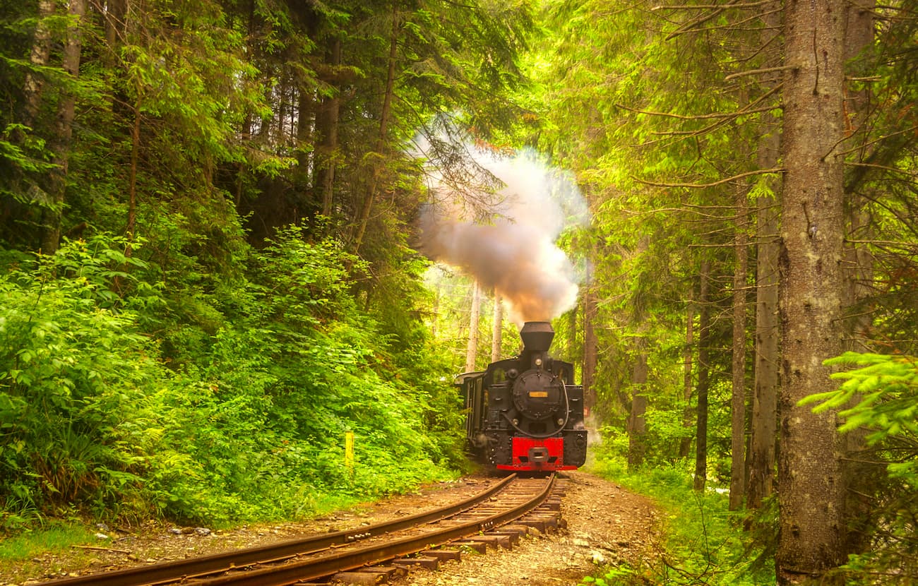
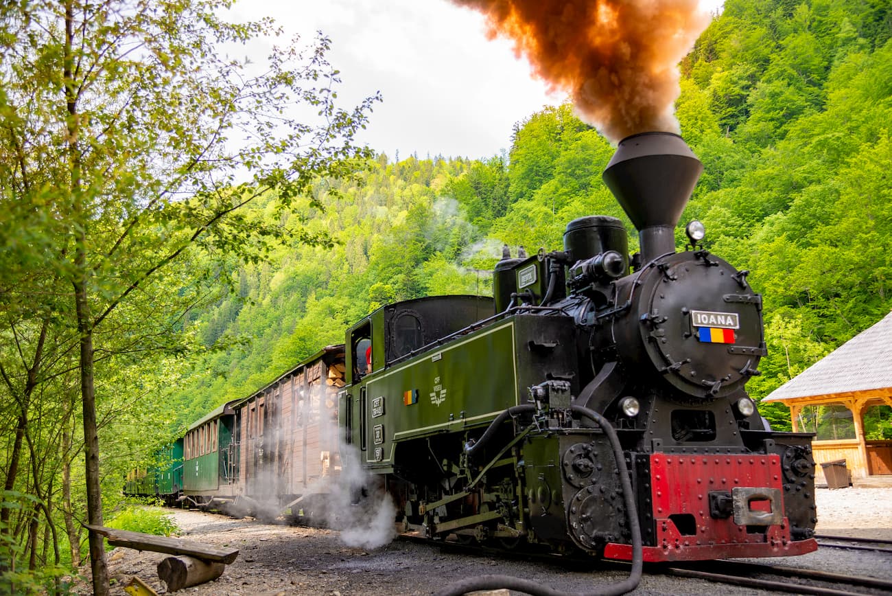
Imagine this: scenic traditional villages, beautiful mountain landscapes, the last logging train of Romania pulled by a steam locomotive and you riding it. In the most northern and largest natural park of the country, you cannot help feeling that you are heading for Hogwarts while riding this fantasy train called Mocanița. But the magic here is different, it is ethereally real. The mild terrain holds magnificent treasures, iconic landscape attractions that seem out of this world. If you want to discover a forgotten land while riding Europe’s last remaining steam locomotive on a forestry railway, just start packing for your adventure in this unique natural park.

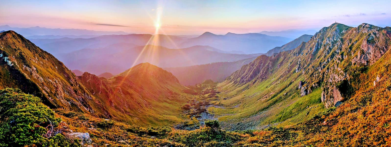
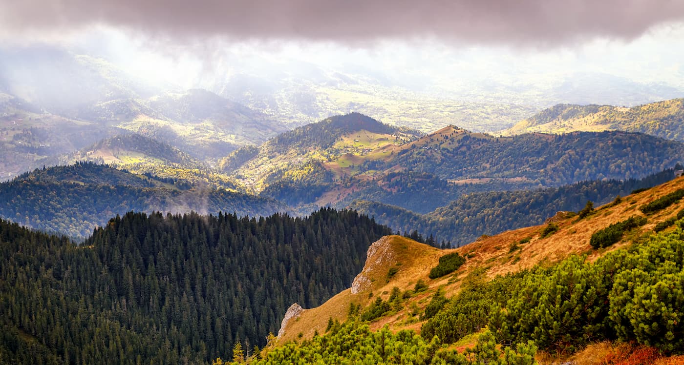
The Maramures Natural Park lies in the north-central part of Romania, close to the Ukrainian border, and in the north-eastern part of Maramures county, in the Maramures Mountains, a mountain range belonging to the Carpathians of Maramures and the Bucovina Mountains. The park also stands on the administrative territories of Borsa and Viseul de Sus cities, the communes Poienile de sub Munte, Repedea, Petrova, Bistra, and Moisei si Viseu de Jos.
You will encounter here fauna and flora that is truly representative for the Carpathians, this being the reason for which 70% of the area is part of the European Ecological Network – Natura 2000. With 1500 sq. km., the park is the largest protected territory in the Romanian Carpathians. However, the size of the Maramures Mountains is much larger than that, with most of the range situated in Ukraine, while the rest is confined to the Maramures basin in the north and east or Romania.
The highest peak of the range is Hovarla (2,061m), it is on Ukrainian land, the highest summit of Romania, Farcau, runs up very closely with its height of 1,957m. The third highest peak is situated in the protected area Farcau, by Vinderelu Lake, it is Mihailecu Peak.

The park consists of four different areas, each a category IV national interest reserve.

You are sure to develop a soft spot for these natural reserves if you’re a true nature lover, a wildlife or plant connoisseur who enjoys plant and wildlife observation. For the more adventure-prone, the diversity of the area will meet every imaginable demand, especially because when you have to do a lot of orientation to make your way through.
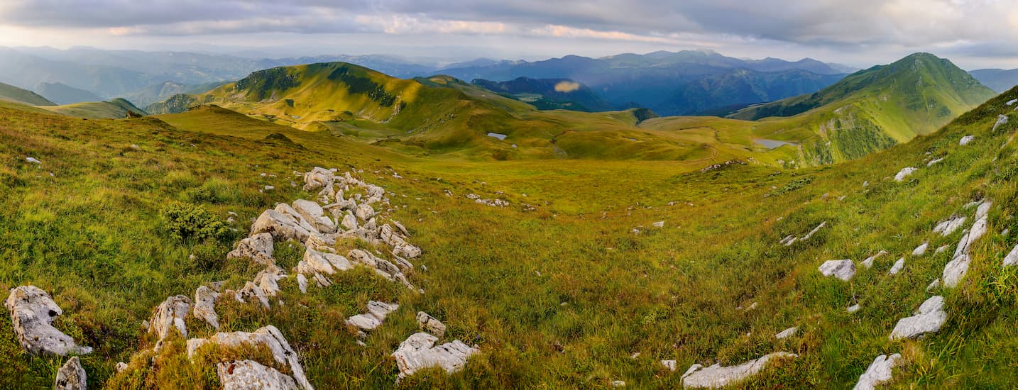
Morphologic fragmentation is the main characteristic of the Maramures Mountains, as the geological substrata generats a morphological variety in high areas, a unique situation in the Carpathians.
The main crest is divided into several massifs, seven to be precise, which are the main tributaries of the Viseu river. However, a specific type of relief developed on crystalline rocks is predominant, it is the one with cupola-shaped massifs and mild ridges. It is not the haggard relief that stands out in the Maramures Mountains, but this type of accessible terrain is present all over the natural park.
Two of the most representative valleys which cross the Maramures Mountains are the Vaser and the Ruscova valleys. They are lying deep in crystalline formations. Over to the north, in the Copilasu and Budescu massifs, the structural relief (fully dependable on the geological formation and the composition of rock materials) is predominant. Some lime traces in the Mihailecu are also of special interest, as is the volcanic relief brought to the surface by erosion (Toroiaga). Also, 32 caves represent the karst morphology of the area. Now, don’t get too excited for underground explorations, as they are relatively small, yet still worth a visit.

Peaks built over metamorphic rocks - Pop Ivan (1,937 m), Serbanu (1,794 m), Greaban (1,594 m) - have steep slopes and blade-like ridge sections, the valleys lying nearby often form waterfall sections.
Peaks built on schists - Jupania (1,853 m), Prislopul Cataramei (1,644 m) - are more gentle, they have smaller angle slopes and sometimes remind of rolling hills.
Peaks built over basaltic Mesozoic rocks - Farcau (1,957 m), Mihailecu (1,918 m) - were shaped by erosion as prominent peaks, with loose rocks and vertical walls, attractive and unique in the Carpathians due to altitude and substrate.
Peaks built over igneous Neogene rocks - Toroioaga (1,930 m), Piciorul Caprei (1,804 m), Tiganu (1,736 m), Magura (1,601 m) - are prominent peaks with steep slopes, the tallest in the Carpathians.

Peaks built over limestones and crystalline dolomite, like Zambroslaviile (1,603 m), are frequent in the Eastern Carpathians, they underline the remarkable morphologic variety of the tall sectors of the Maramures Mountains.
Peaks built over Eocene limestone - Podul Cearcanului (1,507 m), Geamanu (1,539 m) - look like plateaus due to the transgressive sedimentation of limestone over older stratum which determines a levelling.
Peaks built over limestone and Triassic dolomite, like Petriceaua (1,555 m) remind of ruin-like terrain, with spires, knife blades, rocky walls, and overall spectacular views

Peaks built over sandstone - Budescu (1,679 m), Pietrosu Bardaului (1,850 m), Stogu (1,651 m), CopilaSu (1,611 m), Corbu (1,636 m) - are rounded peaks, but prominent and with steep faces.
Although these peaks are very much accessible in summer, winters will put up some serious obstacles. January is the month with the lowest medium temperatures, with values between -6°C and -10°C. The medium annual rainfall is 1100mm. Also, the number of rainfall days is around 150 - 170. You might encounter a serious snowpack piling up already in September, while the last snow might fall at the end of March. Winters are harsh here, so the snow will stay for 120-200 days per year, with an impressive thickness of 75 to 150cm.
You will reach Lucaciasa Refuge by following the TR trail which connects Haitul Macarlau (the Vaser Valley) to Baia Borsa up to Lucaciasa saddle, which separates the Valea Vaserului from Baia Borsa, on the Toroioaga ridge, at 1,620m.
There is a new wooden building in place, with two floors. You will find a large table and some benches on the ground floor, and the bedrooms on the second.
The refuge can host up to 12 people but can accommodate more if you sleep on the ground.
Trail marking: red band
Length: 15 km
Duration:5-6 hours
Difficulty: Medium, difficult in winter.
From Cosnea chalet, the trail descends till the junction with the Paulic Valley. You traverse the Ruscova Valley and keep going on the Paulic Valley road for approximately 500m. Then, start to ascend a zig-zag route among houses of Smereca village. The trail then enters the woods, leaving Socolau Rock behind to your right. After traversing two clearings, you reach the Stanisoara sheepfold found in the alpine pastures near the forest upper limit.

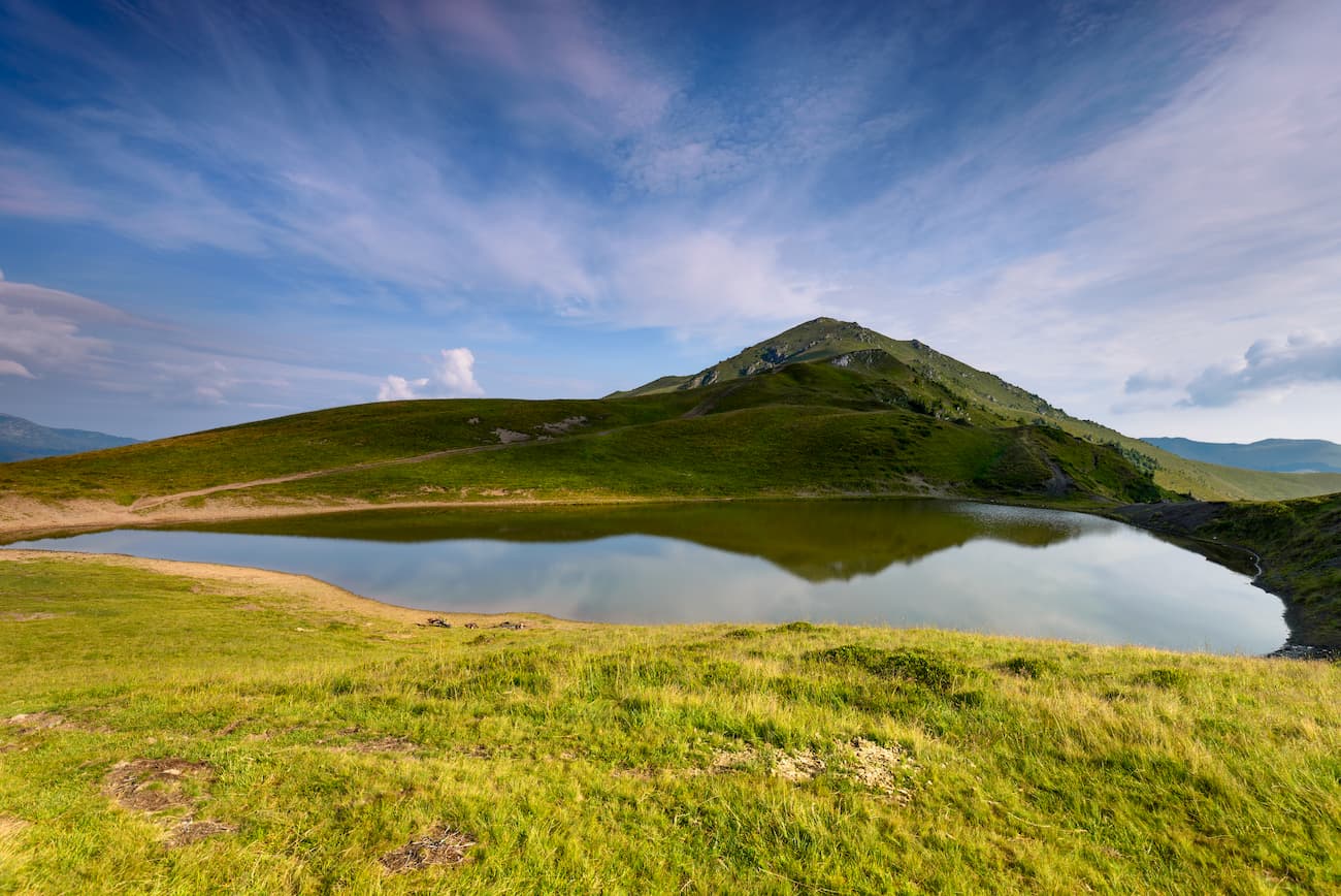
The trail ultimately takes you to the Mihailecu ridge, through a zig-zag path along the forest line. If you follow the ridge among blocks of limestone pavement, you will soon reach Mihailecu peak 1,917m. From this point, the trail descends with quite a sharp drop in elevation towards Vinderel Lake.
Trail marking: red circle
Length: 2 km
Duration: 30 minutes
Difficulty: easy
This easy and short route displays superb scenery and completes the unforgettable experience of the train ride with Mocanita. It unravels the wonderful forests of the Maramures Mountains, as well as the cultural identity of the region. Start from the Paltin station and walk in the cosy shadows of beech and pine-trees. In the summer, you can pick a large variety of forest fruits in the area. There are also to be found unique species of plants and wildlife, long-extinct in other parts of Europe.

The jewel of the crown: a ride on the Mocanița steam train along the Vaser Valley being often called Mocanița from the Vaser Valley, the Forestry Railway of Viseul de sus lies in the north of Romania, at the Ukrainian border. It is a cultural and technical wonder. On a route of almost 60 km (the tourist ride is only 21.6 km, and ends at Paltin station) you will find active steam locomotives, which makes the Viseul de Sus Forestry Railway the last such railway of such kind in the world.
Starting from Viseul de Sus towards the forest, the train follows a country road with a couple of houses. In Delta-Novaț, where the train track forms a junction triangle, the railway takes a right for the next 7 km towards the Novaț Valley, and then turns to the left, along the Vaser river, the tap line continues towards Comanu. Passing through Cozia, Botizu, Faina and up to Comanu, the railway opens up spectacular sights: steep canyons, majestic stone walls, lush valleys with small becks, a staggering diversity of trees and three short tunnels before Botizu. In Faina, just near the train station, you can visit a chapel built by Austrian colonists for Princess Elisabeth, also known as Sissi.
Trail marking: red triangle
Length: 15 km
Duration: 5 – 6 hours
Difficulty: Medium, difficult in winter.

The tourist trail starts from Macarlau, a stone-built dam and a unique tourist destination in Romania. From there, you cross the Vaser river, descend on the left bank, past the bridge over the Macarlau valley and then take an industrial road leading to a former mining colony, found at the junction with the Lucaciasa valley. Pass the colony and follow a winding path towards the mine galleries.
The marking follows the ridge between the Macarlau and Lucaciasa valleys, up to Lucaciasa mountain refuge found in the north of the homonym saddle, with the spectacular ridge of the Toroioaga Massif to the right. Its tallest peak is Toroioaga Militara (1,930m), and the one you see to the left is Piciorul Caprii (1,804m).
From Lucaciasa saddle (1,641m), the route descends through the woods, past some other mining galleries, and from here it takes an industrial road to the former Gura Baii colony, to the place called La Taietura. From here, the trail has a section cut in stone, then the marking takes a right on a ravine, reaching the 23rd August mine. Finally, the trail descends even farther, reaching the centre of Baia Borsa village. All the way down you will be admiring the north face of Pietrosu Rodnei (2,303m) and its three glacial cirques.

Viseu de Sus is a city in the Maramures county, actually composed of two municipalities, Viseu de Mijloc and Viseu de Jos. The city is a tourist resort, given its position near the Maramures Natural Park. You will find that it holds a lot of tourist attractions, a variety of churches, museums, photo exhibitions and a fully preserved Jewish house. Also, this is the place to start the wonderful journey on the Vaser Valley through nearby tourist trails.

Borsa lies at the feet of the Rodnei and Maramures Mountains, thus having an attractive natural landscape and numerous touristic resources. The city is surrounded by Pietrosul, Negoiescul Mare and Zapezii peaks, making it the ideal starting point for many hiking routes in the area. Besides hiking, you can access from here a lot of Maramures attractions, such as the Merry Cemetery (Cimitirul Vesel) of Sapanța, Izei and Vaser Valley, Izvorul Negru Church or Baia Mare and Sighetul Marmației cities. In your journeys around Borsa, make sure you also visit the Horses Waterfall (Cascada Cailor) near Borsa - Complex resort, to the north-east of the Rodnei Mountains.

Explore Maramures Mountains Park with the PeakVisor 3D Map and identify its summits.