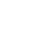
Starting from the village of Aiguebelette, this tour will take you to one of the most beautiful viewpoints of Lake Aiguebelette: Mont Grêle. The first part of the route is difficult, containing all the difference in altitude of the route (1160m+ over 7km). The regular slopes up to km 4.5 will nevertheless allow you to run before attacking a steeper part to reach the summit. You will then enjoy a flatter section at the top before continuing downhill to reach the Col Saint Michel and then the Col du Crucifix and finally Aiguebelette village. The itinerary takes place in a forest atmosphere, with a succession of paths and tracks that are very pleasant to run and that will not leave you indifferent ! Definitely one of the « must-to-do" routes of this Espace Trail !
- Distance 17.9 km
- Elevation gain 1260 m
- Elevation lost 1260 m
- Min. elevation 393 m
- Max. elevation. 1434 m
- Duration (depending on pace) 2h30 à 5h
- Marking Trail running n°8 red + hiking signs